nordhavn
Spatial Development Concept:
The spatial development concept aims at generating an urban, compacted district with short connections, ecologically sustainable, largely preserving the material, natural and social substance and taking advantage as much as possible of the existing scenic qualities. The characteristics of Nordhavnens urban space are its scenic consistency, the presence of water, its natural qualities and the existing buildings and facilities. The proximity of the southern development area to Østerbro district is seen as an additional advantage of location. In the development area, particular attention is paid to the existing buildings and facilities, serving as nuclei for urban growth, and to the issue of “borders”, offering an appealing borderline experience between land and sea, city and landscape. The spatial development model is intended as a flexible and open-ended concept, due to be refined and concretized in the process of further evolution. An ensemble of development strategies serves as framework for Nordhavnens formation in the various stages. These superimposed strategies allow for an integrated development of the new district, also under changing circumstances.
Development Strategies:
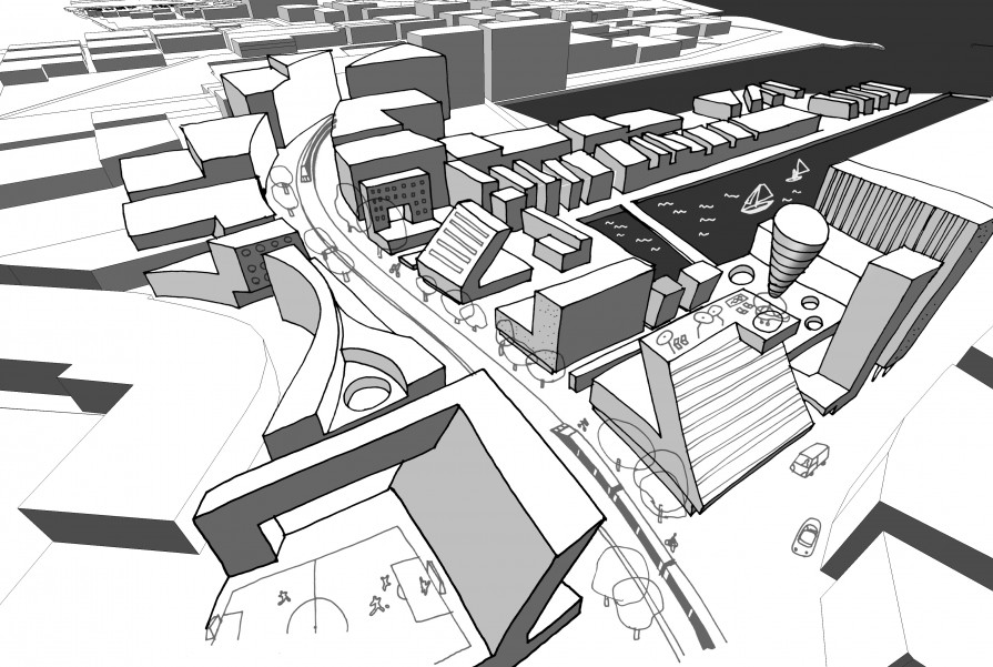
Development Nuclei – Instead of establishing a holistic master plan, the development starts at the places where there is already something to fetch: Åhusgade, Kronløbsbassinet, Fiskerihavnen, Kalkbrænderiløbet. The existing buildings and facilities, but also the landscape in the outer northeast and around Skudehavnen are seen as nuclei for development. These nuclei get overlaid with new functional areas and with a network of infrastructural and strategic interventions. Thus, by overlaying and by realigning, breaking down and reinterpreting the existing substance, a robust framework for the districts urbanistic formation comes into being. This framework also constitutes the backbone for the further development of Nordhavn.
Development Axis and Central Areas – The projected Metro line works as a central development axis, along which two central areas evolve: the center of Åhusgade as a vital urban core zone and as relay to the Østerbro district, and a new central area in inner Nordhavnen at the Metro station between Skudehavnen und Skodeløbet. The development axis is largely shaped as a wide, civic boulevard, seamed by mixed-use buildings. The raised Metro line is a token of modern and ecologic city transport and offers numerous views over the new district and the existing landscape. The development axis is part of a network of free spaces, connected by a dense grid of lanes, squares and promenades with the wider landscape and city.
The Grid, the Free-Space Network, the Ground Floor – An orthogonal grid, aligned with the existing embankments and for the most part oriented in east-west and north-south direction, secures optimum traffic accessibility and divisibility of lots. The grid can also be seen as a system of views, which every now and then lay open the horizon and, in their wideness, make tangible the presence of landscape and sea. A system of diagonals, passages and breakthroughs for cycle- and footways (“wormholes”) allows for an optimum and environment-friendly accessibility in the entire district. This system overlays the grid and the plots, bridges over existing buildings and facilities and establishes itself as a network of direct connections. At the intersections with buildings, squares are placed. Thus a higher-ranking network of free spaces is created, which makes it possible to experience the new quarter in an appealing way.
An essential part of the free-space network as a public area are the ground-level facilities, working as an interface between interior and exterior. In these areas and spaces of contact a large part of peoples’ day-to-day experience is taking place. Everyday occurrences happen, and they mainly thrive on this ground. Hence, particular attention is paid to its definition and utilization.
Concept of Green and Free Spaces: The design of green space has two objectives: First, a maximization both of contact areas and of usefulness. As many residents of the new quarter as possible should be close to the green (“To the park in no more than two minutes”). Second, its structure offers view connections and makes it possible to experience the typical marine landscape.
As a scenic space, it is a continuous element, which one can walk through and experience visually, where one looks for to stay. It is a compound of soft natural and hard urban zones, of areas for games and sport and of landscape, left in its natural form. Because of its size, it defies all-dominant claims of utilization. Its design, above all, is aimed at public, day-to-day usage.
Building Lots, Residential Quarters – The locations of the different residential quarters are chosen in such a way as to ensure closeness to the green space and / or the water, but also to the central area around the Metro. The objective is to develop compact urban quarters with high quality surroundings and good transport connections.
The residential quarters densify near the urban core area, they are tightly intertwined with the green and free areas and superimposed with the numerous development goals.
“Wormholes” provide fast cycling connections to other parts of the city. Visual axes uncover the horizon and public transport bus lines establish accessibility in an optimal way. For the purpose of dealing with available resources in a space-saving way, gross floor area should average 2,0 times lot coverage. Due to the structure of the built-up area, the location of axes and the stepping of building heights, lots of various views are possible also from the second row. The buildings on the individual lots are to be designed in a cooperative planning process, in order to achieve the greatest possible coordination between the single developers and the future occupants.
Borders: Particular attention is paid to the issue of “borders”. The existing coastal rims get diversified into places for encounter, change, tranquillity and outlook. Promenades, beaches, coastal areas and the border zone between compact built-up area and landscape are characteristic features of the new district. The location near the sea and the new can be experienced intensively.
In designing the residential quarters, the topic of “living at the border” is to be approached in different ways.
Maintenance of assets: One basic intention of the development concept in terms of sustainability is a strategy of maintaining existing assets. Existing qualities and facilities are taken as nuclei for development. They get evolved out of themselves, consolidated, completed and integrated in the overall process by the higher-ranking development goals.
The existing assets are taken as identification marks and strengthened.
Maintaining the existing also means to consider a places history. To Nordhavn, its history as a harbour area is given to take along. This history constitutes a symbolic asset and, through landmarks, orientates the mental map of future residents and visitors.
Accessibility, Traffic: In addition to the Metro as an efficient means of public transport, bus-, cycle- and footways make accessible all parts of the new quarter.
Individual motor car traffic is conducted by access roads and loop lines. Through traffic is inhibited, the residential quarters are largely kept car-free. A dense grid of landings for water-taxis and shuttle boats optimizes both accessibility in the quarter and connections to the city.
A Mixed Quarter: An essential aspect for local integration and for economic and social sustainability is the development of a quarter with mixed functions. For this purpose, there is a large choice of spaces on street levels as well as in the existing halls. The ground levels should, for the better part, have a ceiling height of about 4 meters. A quarter management supports and actively promotes the settling of locally entrenched businesses. In compensation for additional bonus volume, developers can provide low-priced spaces to the quarter management. Within the scope of the cooperative planning process, different forms of ownership and integrative living projects are stimulated and thus support the creation of a mixed and diversified quarter.
The existing buildings and facilities in Åhusgade are valued as specially important. Here a vital, urban quarter with its own central area and separate character is to emerge. In the Kronløbsbassinet area the existing commercial facilities are to be extended with appealing cultural institutions.
The existing service location Kalkbrænderiløbet is to be upgraded into a commercial and service cluster with technical college, training centers, institutions for research and development. Moreover, it is to be connected with the urban center around Åhusgade. Fiskerihavnen is maintained as an independent, high quality urban area.
Quarter Management, Office for Sustainability:
Right from the start, the development of Nordhavn is to be coordinated by a quarter management, a central contact point, where planners, politicians, citizens and an urbanistic guiding team (competition jury), all participating in the development process, concur. An office for sustainability is affiliated to the quarter management. It coordinates the development strategies for ecology, energy, environment-friendly construction management, sustainable materials usage, adaptability of buildings and compiles ecological and life-cycle balance sheets.
The central ecological aspects are sustainability, durability and flexibility of the new buildings. The objective is to operate the new quarter in a sustainable way by building maintenance, economic management and lasting utilization.
To this purpose, there is the requirement for flexible zones on the ground levels, the possibility to rearrange the residential structure according to changing circumstances and necessities, the realization of a mixed-function compact quarter with short connections, and the increase of benefit by high comfort, urban infrastructure and architectural quality.
Sustainable city, Ecology: On the level of the spatial development concept, in terms of the strategy for a sustainable city, the most relevant aspects are the structure of the quarter, its accessibility, and, in regard to the chronology, an environment-friendly construction site management. It is primarily about minimizing both lorry traffic by avoiding unnecessary rides and construction waste by recycling building materials as much as possible.
In order to reduce lorry rides by more efficient utilization, a road charge for construction vehicles, depending on their emissions, is levied.
Moreover, it has to be verified by an environmental audit if construction traffic can be shifted to ships or trains.
Recyclable materials, which are easy to dismantle, are to be used for the new buildings. In order to optimize the turnover of construction materials, a logistics center should be established in Nordhavn.
All these measures are to be implemented, monitored and valued by the office for sustainability as part of the quarter management.